Martuwarra: Living Water Heritage of the Kimberley
The research team initially set out to understand the effects of climate change (flooding and bushfires) on cultural heritage, specifically rock art and sites of Indigenous resistance to European colonisation/invasion.
First published by The University of Western Australia
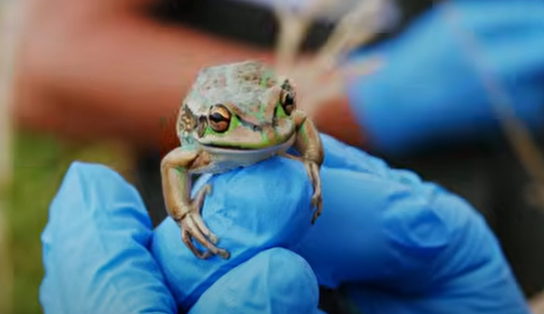
Western Australia’s Kimberley is vast and rich in cultural heritage and includes significant rock art sites dating back as far as 41,000 years. The West Kimberley region is also a National Heritage listed area.
Disturbance of these sites from human intervention and climate change, including the once-in-a-century flood of 2023, has resulted in damage to cultural and natural heritage and wildlife, and loss of life. Whilst the history of these sites has been passed down orally through stories, they had never been systematically geo recorded or documented for their cultural significance.
Martuwarra RiverofLife
Martuwarra covers 96,000 km2and at 733km It is the longest registered Aboriginal Cultural Heritage site in Western Australia and is National Heritage listed for all 11 heritage values. For Aboriginal people, Martuwarra is a sentient Being that enables life and activities. Many communities use Martuwarra as an economic, social and spiritual resource.
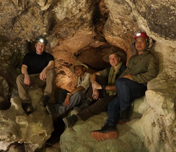
Researchers from the UWA’s Social sciences Disciplines of Archaeology, Anthropology and the Centre for Rock Art Research + Management have worked closely with over 60 Traditional Owners, youth and Rangers from multiple Kimberley communities to produce a site mapping framework of the Kimberley and Martuwarra under three main categories mandated by Aboriginal partners: Culture, Country and Truth. Whilst the project continues to grow, it has for the first time produced an extensive, systematic and holistic survey and mapping of cultural heritage, including significant sites and people along the river’s length.

Working together
The research team initially set out to understand the effects of climate change (flooding and bushfires) on cultural heritage, specifically rock art and sites of Indigenous resistance to European colonisation/invasion. The living tradition of the Kimberley sees some of the many rock art traditions continue to be made and maintained today – such as the Wandjina/Wanjina tradition.
They also wanted to record sites of archaeological and social significance and have them known to as many stakeholders as possible – to complement the land management practices of Indigenous Rangers and government, and to enable respectful discussions with outside parties seeking to use the water and mineral resources of Martuwarra. As one Elder said “two ears, one mouth” so mostly, we listened.
The Kimberley Land Council also identified early in the research that getting people onto Country was a crucial project outcome. The Kimberley has one of the highest suicide rates in the world and for Aboriginal people, spending more time on Country and doing cultural activities is strongly tied to better physical and mental health. Through their activities, the team enabled several hundred on-Country days for men and women, and the young and old, where intergenerational knowledge transfer was encouraged as a key component.
Underpinning these goals, the team commissioned subject experts to write ~50,000 word’s worth of short accessible articles pieces on geology, archaeology, ecology, and heritage management resulting in the digital StoryMap acting both as site repository and archive, and advice centre for anyone wanting to work in the area.
“We do everything through a hierarchy: First is Martuwarra, and there’s the old people and the younger generation, then there’s us. We value the Elders as a repository of knowledge, and they enable all things and keep us physically and culturally safe.”
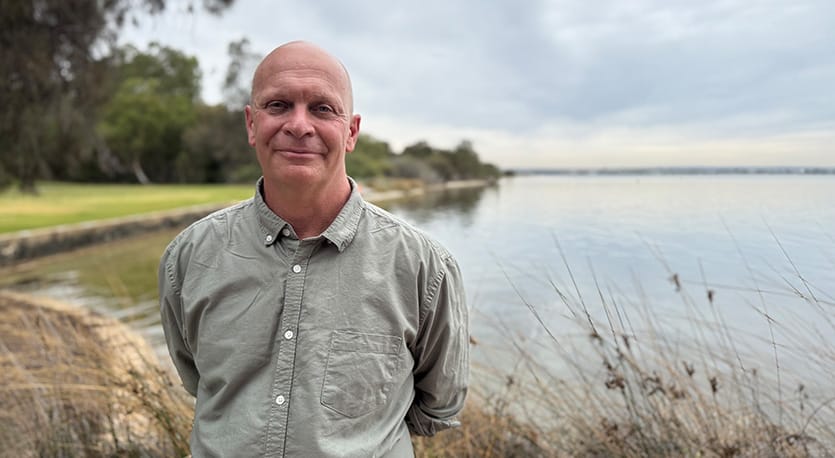
Associate Professor Sven Ouzman, UWA

Living Water
A major component of the research outcomes was the development of the interactive digital Living Waters Heritage StoryMap to capture the heritage values and map sites so that future impacts on the region can be identified and managed proactively. Community Elders were interested in a map showing where places of interest were, so that they could be properly looked after, and a way of showing the relationships that have been established between communities in the region.
The team launched the online platform Living Water in 2024. The site was designed for multi-purpose use by Traditional Owners, schools – as Australians tend to know very little about archaeology and Aboriginal heritage, government, industry and the public using an interactive ‘StoryMap’ format.
The project was made possible by Martuwarra, RiveOfLLife which has been credited as first author of the research, the Commonwealth Department of Climate Change, Energy, the Environment and Water with an Australian Heritage Grant and the team’s close partnership with the Martuwarra Fitzroy River Council (MFRC) that represents the nations living along the Martuwarra.
“These nations are all very conscious of how activities in the area affects their neighbours. Whether it be natural like a flood, cultural, or actions such as fracking on the landscape. So, a recurring catchphrase from which we all could learn is “water flows down”.”
Associate Professor Sven Ouzman, UWA

The project leads are:
- Indigenous Lead, Nyikina Warrwa woman and academic from the Kimberley Professor Anne Poelina, Martuwarra Fitzroy River Council and The University of Notre Dame
- Academic Lead, Archaeologist and Heritage Specialist, Associate Professor Sven Ouzman, School of Social Sciences at The University of Western Australia
- Project Manager Lachie Carracher, Martuwarra Fitzroy River Council
Though substantial research on ecology and heritage has been conducted over the decades in the region, this information is often in the form of academic articles and is hard to access for Martuwarra residents and others. This imbalance led the team to develop more accessible resources for the StoryMap platform, such as posters, short articles, lots of first-person testimony captured as video clips, video of the region and its heritage. These formats and content were approved by Traditional Owners who were keen to have simple and clear content that school children and everyone living along Martuwarra could understand as well as outsiders like tourists, government and industry.
School teachers further afield also appreciate the downloadable resources which are short and offer messaging on sites and relays the knowledge in a safe and culturally appropriate way. While many school syllabi include Aboriginal heritage present and past, they often lack reliable, approved content, which the StoryMap provides.
An overview of the StoryMap’s three main themes is as follows:
- CULTURE: celebrating at least 50,000 years of cultural connection to Country, it includes the diversity of nations and language groups, Songlines and Stories, and the importance of First Law which governs the responsible management of Martuwarra. The spirit of First Law is that it is particular to a place and sets out the reciprocal relationships and obligations between place and people. This section has numerous video clips of people talking about their knowledge of Martuwarra.
- COUNTRY: acknowledging the power of Country and the complexity and wonder of a landscape that commands reverence and respect. Its is in this section that most of the short commissioned academic-authored pieces are.
- TRUTH: demonstrating that the treatment, resilience and adaptation of Aboriginal people from the Kimberley is a part of the Australia’s heritage. It includes new information on missions, pastoral stations, Australia’s last leprosarium, and Noonkanbah which put land rights on the national political agenda, and the story of one of Australia’s longest, most successful resistance rulers against the British in the 1890s, Jandamarra (Pigeon). This includes previously unrecorded testimonies on colonial frontier violence, further work on which represents a next phase of the project.
“This project was an important test case in digital storytelling, how to handle cultural heritage, and in who has access.”
Associate Professor Sven Ouzman, UWA
A Story-Telling Map
The map section includes a layer of sound snippets, quotes or pictures and videos of life along Martuwarra and its heritage. Longer interviews with people and their stories are stored here. Across 18 months, the team travelled along the 733 kilometres of Martuwarra to interview over 60 traditional owners. The site records their voices and thoughts and provides a platform for knowledge, truth telling, healing and reconciliation. These videos blend Aboriginal and academic knowledge in a multi-way learning exercise while also representing a documented record of Martuwarra’s on-going history and heritage to ensure knowledge flows to a younger generation.
The interviews chart how the region has changed from an environmental standpoint. Mapping sites allows researchers and rangers to look for trends in the larger landscape. For example, 20,000 years ago during the Last Glacial Maximum or ‘ice age’, there existed another half a million square kilometres of land in the Kimberley (the Kimberley today is 423,000 km2) which is now underwater. Using bathymetry (the study of underwater depth of ocean floor), researchers can use our StoryMap data to predict where underwater land sites might have been to provide a more complete picture of the heritage of the area.
“The benefit of going to someone in the place where they live is they’re in their Country, they’re the boss, and they’re authorised to tell their story. Some of these are hard, hard stories.”
Associate Professor Sven Ouzman, UWA
Using a ‘heat map’ approach is particularly useful for local people who may have forgotten about these places, can no longer make their way to visit them or need to identify places that should not be visited by their people. And it allows the youth to see their country in a new way and with a higher value. It also allows everyone to look beyond individual sites but consider how sites relate to each other and what the wider cultural landscape is, even if parts of it have no visible artefacts or signs of human activity. People sometimes ask, “Which parts of Australia are someone’s Country?” to which the answer is “All of it”.

Cultural Competence
In addition to the short, commissioned pieces on geology, flora and fauna, archaeology and rock art, Traditional Owners asked us to write an ‘Indigenous Engagement 101’ document. This is due to a constant stream of requests from outsiders to work on Country be it for academic, commercial, recreational or other purposes. People often mean well but don’t always understand how few people live on this vast landscape (around 16,000 people in Martuwarra’s catchment). In the ‘Heritage Management‘ document, the importance of reading the ‘Healthy Country’ decadal plans of Aboriginal Corporations, of the importance of face to face engagement, of being aware of cultural protocols are emphasised using examples, showing the relevant Aboriginal and Western laws, and handy tips.
Managing Change
For government land management agencies like the Department of Biodiversity, Conservation and Attractions, the StoryMap easily identifies areas of special significance (all of Martuwarra is significant at a basic level) that require a greater level of care when conducting annual burning. For example, if a site includes paperbark burials, it might require spot burning by specialist local rangers as part of a Healthy Country Plan protocol that brings together nature and culture. By burning a rock art site in a culturally appropriate way, the ‘natural’ health of the ‘cultural’ site is cared for; ultimately bridging the unhelpful nature-culture divide that informs many land management policies. Further, this mapping and recording can aid when making decisions about tourism and which areas are appropriate to visit and which are not – making visitors understand this is not a pristine ‘wilderness’ but a carefully curated cultural landscape.
The StoryMap is also available to commercial interest especially in the pastoral and resources sector. This is crucial given increasing demands for water extraction, fracking and mining. While these entities all have codes of conduct, they are often general and don’t understand, for example, the personhood of Martuwarra, or the negative mental and physical health risks to development not sensitive to on-ground cultural practices. By having sites precisely geo referenced and described ensures there is pre warning about sites they should not approach, saving time and money. Note that precise site locations are not provided on the StoryMap to work against unauthorised visitation and to respect Indigenous Cultural and Intellectual Copyright and Data Sovereignty), these are made available on a per-project basis after an initial agreement has been reached with all parties. This approach empowers Indigenous people to receive proper compensation, acknowledgements, and provides a platform informed by Indigenous knowledge and academic research, that gives people the power to say ‘no’ if any project seems sub-optimal.
River Keepers
An important part of the project was to provide a platform for Martuwarra to be cared for while facilitating sustainable on-Country employment and engagement. People are keen to live and work on Country, and particularly the youth. They feel connected and strong on Country and see heritage as a field that can sustain them over a long period.
The project provided a new initiative known as the River Keepers with science-based heritage management skills and how they link more broadly to legislation, and archaeological skills, using the Australian Archaeological Association Skills Passport, which provides a record of a person’s journey through archaeological training and recognition of their knowledge.
Reciprocally, the River Keepers provide invaluable knowledge to the academic team, such as information about new sites and daily experience of the effects of climate change that are not always captured. For example, climate change, along with human impacts, has led to wattle trees growing densely along the banks of Martuwarra. This prevents the cooling breeze blowing off the river and travelling to communities who sensibly live beyond the flood zone from reaching the people in these communities where summer temperatures approach 50 degrees Celsius. Further, water is an important spiritual link and provides food to families who may not have many employment or income options.
“Rivers are great connectors between different areas, and they act as proxies for kin and other connections. Even if there isn’t a direct connection with someone, there is a story that connects people and sustains them.”
Associate Professor Sven Ouzman, UWA

LARA
Together with the Kimberley Land Council, the team developed an app called LARA (looking after rock art). The app includes a section for researchers which includes field work information, and a section used by rangers in 13 different Ranger groups to help them locate sites in their area, describes what can be found there (e.g. stone tools, rock art etc), the threats to the site, and what action needs to be taken. The app also allows management of possible carbon credits which helps the 13 communities in the region remain self-sustaining and sustainable whilst boasting the competitive edge of looking after cultural heritage rather than threatening it.
Flowing Forward
The Living Water Heritage project has been recognised with a 2024 WA Heritage Award, in the Interpretation Project category. This was the first time in the 32 year award’s history a large cultural landscape project has won the award, a recognition of the growing awareness of the need to consider and manage heritage holistically.
Subsequent to this project, the team will produce a book showcasing the stories and images of the region, with a focus on the anthropological and ethnographic aspects of the project in accessible format for people who lack or do not want to engage with the digital StoryMap.
The team is also planning to add to the platform to better inform tourists and display walking trails along Martuwarra. This is intended as a potential source of income for locals as guided walking trails for hikers, in pointing out particularly cultural and natural sites.
For Associate Professor Ouzman, the project has been exciting and humbling. The story is an important one to tell and helps to fill a gap in archaeological research. And working with Indigenous people on recording the heritage of this rich cultural history continues to inspire his work. The team are proud to be a part of a project that provides a valuable resource to those who cannot visit the Kimberley.
“I’ve always loved archaeology and just the notion that there’s literally a world below your feet never fails to amaze and inspire – and it’s fun! “
Associate Professor Sven Ouzman, UWA